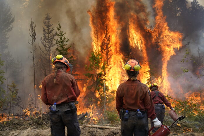
Crews have been able to get a handle on the Dogtooth blaze near Golden and the fire is now classified as being held.
The fire is not expected to grow past the current containment lines.
The fire grew to 5,680 Hectares since being discovered on July 22.
At least six homes were destroyed along Rauch Road.
Out of Control wildfires:
Mount Morro – N21014 – Located in Top of the World Provincial Park (currently closed)
- Size – 11,903 hectares
- Suspected cause – lightning
- Discovered on July 17, 2024
- An Incident Management team has been assigned to the fire.
- This fire originated at high elevation on Mount Morro, in extremely steep terrain that is inaccessible to crews.
- This fire is classified as a modified response. Wildfire Officers and an initial attack crew have worked with BC Parks to protect park values.
- A local initial attack crew is working on a consolidation of guards in the Fish Lake area
- Structure protection has been established on cabins outside of the park in areas of concern.
- The evacuation for four properties, the Home Basin Campground and Inlet Creek Campground has been rescinded.
- The area restriction in place was modified and shrunk along the north and south sides of the fire.
- Travel along the Whiteswan FSR is permitted.
More: BC Wildfire Service shrinks restricted area around two local wildfires (Aug 7, 2024)
Lost Dog – N21284
- Size – 899.4 hectares
- Suspected cause – Lightning
- Discovered on July 20, 2024.
- Helicopters will be seen in the area of these fires as they are being flown regularly for reconnaissance.
- BC Wildfire Service officials said direct attack suppression on the north flank was successful and it kept the fire south of Skookumchuck Creek.
- An area restriction has been put in place.
- Rain and humidity have reduced wildfire activity to smouldering ground fires.
- There are currently two initial attack crews, four contract crews and three single resources responding to the fire.
MORE: Area restriction in effect for Lost Dog area (July 29, 2024)
Ravenshead – N21610
- Size – 8,615 hectares
- Suspected cause – Under investigation
- Discovered on July 24, 2024
- The evacuation order for nine properties in the Palliser/Cross River area has been rescinded.
- This includes Nipika Mountain Resort, Cross River Education and Retreat Centre, Cross River Forest Service Road and Cross River Canyon Recreation Site.
- Due to safety concerns, travel on the Kootenay-Settlers FSR (Ravenshead) and Palliser FSR’s is not permitted at this time. This will be reviewed daily.
- The area restriction was reduced along the south side of the fire.
More: BC Wildfire Service shrinks restricted area around two local wildfires (Aug 7, 2024)
Bradford Creek – N11212
- Size – 41 hectares
- Suspected cause – Lightning
- Discovered on July 19, 2024
- Steep, rocky terrain has presented safety hazards to ground crews.
- Direct attack tactics are being used on the parts of the fire that are closest to the valley bottom.
- Helicopters will be seen in the area of these fires as they are being flown regularly for reconnaissance.
- Rain and humidity have reduced wildfire activity to smouldering ground fires.
Wildfire being held:
Dogtooth FSR – N21427
- Size – 5,680 hectares
- Suspected cause – Lightning
- Discovered on July 22, 2024. Remains a wildfire of note.
- The Town of Golden confirmed that at least six homes have been destroyed along Rauch Road.
- An Incident Management team has been assigned to the fire.
- The evacuation order for properties on Malone Road, Parson River Crossing FSR and Thomas Road has been downgraded to an alert.
- An evacuation order remains in place for 4490 Thomas Road, 2104 Highway 95 South and all properties on Rauch Road.
- The evacuation alert for 339 properties from Hawkins Road to approximately two kilometres south of Parson is still in effect.
- An area restriction is in place.
More: Evacuation alert partially rescinded for Dogtooth blaze (Aug 7, 2024)
Wildfires under control:
Leach Creek – N12216
- Size – 0.009 hectares
- Suspected cause – Human
- Discovered on Aug. 14.
For more information on specific wildfires in the region contact the Southeast Fire Centre at [email protected] or 250-318-7715.
More Information
The BC Wildfire Service is the primary source of information for all wildfire activity.
Regional District East Kootenay (RDEK) is the primary source of information for evacuation orders and evacuation alerts.
Drive BC for all information on roads and road closures.
Be the first to know! Don’t miss out on breaking news and daily updates in your area. Sign up to MyEastKootenayNow News Alerts.


