An area restriction has been placed around the Mineral Creek wildfire as other significant fires around the region continue to grow.
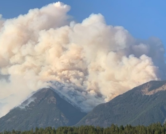
As of Monday afternoon, the Mineral Creek wildfire is about 58 hectares in size in an area that is about 25 kilometres southwest of Invermere.
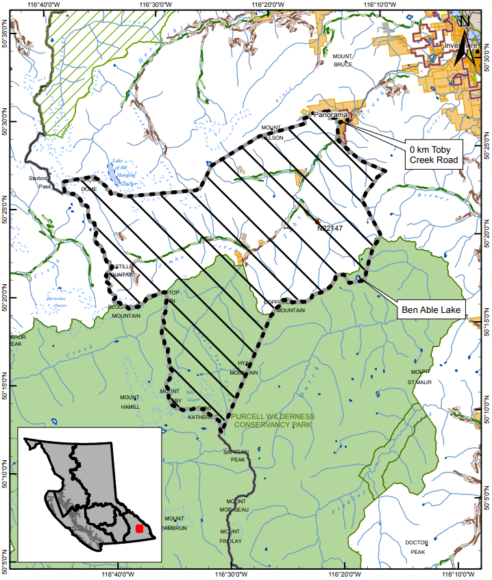
The area restriction runs from Panorama in the north to Mount Katherine in the south. A map can be found at the end of this article.
Access to Ben Able lake has been closed off, meanwhile Toby Creek Road has been closed to traffic.
This means that the public will only be able to enter and exit the vicinity for specific reasons, such as using the highway, travelling to and from your home, as long it is not under an evacuation order, or if you are helping firefighting efforts.
The BC Wildfire Service is responding with five firefighters and two pieces of heavy equipment.
“Crews are working to install a wetline, which is a series of sprinklers along a fuel-free area to reduce the spread of low-intensity fire. More resources are expected to arrive on this fire today,” said BC Wildfire Service officials.
A number of other area restrictions are active around the East Kootenay and Creston Valley.
More: Area restrictions enacted around three East Kootenay Wildfires (July 19, 2021)
More: Akokli and Redding Creek under area restrictions (July 14, 2021)
Notable fires
Three other wildfires of note are burning in the region, the largest fire is the 2,665-hectare Cultus Creek wildfire, west of Kootenay Lake.
Although, the BC Wildfire Service (BCWS) said the fire will not be considered a fire of note by the end of the day on Monday.
The Evacuation Order has been downgraded to an Alert for properties between Midge Creek and Next Creek.
Signage has been posted to alert the public that Midge Creek Park is closed.
No firefighting equipment is on the scene of the blaze.
“Firefighters completed objectives around the Tye Beach cabins the afternoon of Sunday, July 25. Some equipment remains on-site in the event the need arises to return and protect structures. BCWS personnel will continue to monitor this fire, which remains very active,” said BCWS officials.
Across the lake, the Akokli Creek wildfire continues to burn and has grown to about 1,912 hectares.
Crews are responding to the blaze with 41 firefighters, four pieces of heavy equipment and three helicopters.
“Firefighters are mopping up and reinforcing along the fire guard from the Akokli Creek drainage to the western aspect, where the fire has come close to the containment line. A heavy equipment guard has been constructed from the Akokli Creek drainage,” explained BCWF officials. “The fire currently remains within the containment lines. Due to increased fire behaviour in the early evening and into the night, crews will remain on-site to monitor the fire and action it where it is safe to do so.”
The Bill Nye Mountain fire, about seven kilometres southeast of Wasa is estimated to be about 1,107 hectares in size.
Nearby properties are on an Evacuation Alert, while a handful of select properties are on Evacuation Order.
28 firefighters are responding to the fire with three pieces of heavy equipment and two helicopters.
A planned burn was scheduled for Sunday, and it only partially went through because of the day’s conditions.
“Due to increased fire activity in the north part of the area, planned ignitions were halted. Ground crews will monitor and mop up the strengthen the anchor point on the south and southwest flanks. Crews will continue to line locate for heavy equipment to establish machine guards to protect structures along the west flank. Helicopters will continue bucketing to support ground crews. Aerial monitoring of the fire is ongoing. Heavy equipment is constructing a machine guard along the west and north flank and around structures,” explained BCWS officials.
More: One more property under Evacuation Order, planned ignitions scheduled as Bill Nye Mountain fire burns (July 24, 2021)
Out of control fires
The Carney Creek wildfire is believed to be about 777 hectares after it was discovered on July 11th. The fire is burning in the Purcell Mountains, north of Purcell Wilderness Conservancy Provincial Park.
Another 381 hectares of forest are burning out of control near Kamma Creek, southeast of Kianuko Provincial Park. The fire is in the Moyie Mountain range, northeast of Creston.
A 325-hectare burn is out of control in the Tanglefoot Creek area, about 30 kilometres northeast of Cranbrook. It is believed to have been sparked by lightning and was discovered on Friday, July 16th.
The lightning-caused Redding Creek wildfire, east of Kootenay Lake, is estimated to be about 166 hectares in size after it was first discovered on Sunday, July 11th.
A 58-hectare fire in the Dewar Creek area, about 58 kilometres northwest of Kimberley is continuing to burn out of control after it was discovered on Friday, July 26th.
In the Ptarmigan Creek area, north of Whiteswan Lake and about 23 kilometres northwest of Canal Flats, a 62-hectare fire is active and is out of control.
Area restrictions have been put in place around the Tanglefoot, Ptarmigan and Dewar Creek wildfires.
In the Armour Creek area, a 15-hectare wildfire is also burning out of control.
Fires being held or under control
Firefighters have gained hold of two wildfires in the region: a 0.6-hectare fire near Forsite, along White River and a 26-hectare burn in the Granite Creek area in the Purcell Mountains.
Three wildfires across the East Kootenay are under control, including a 29-hectare wildfire in the Moyie River area and the 11-hectare blaze near Big Lake, east of Highway 93, south of Wasa.
The Bear Creek fire is also under control at 1.5 hectares in size.
More: BC Wildfire Service dashboard


